


Dientes de Navarino Backpacking 2023 - Adventures at the End of the World in Patagonia, Chile
For those interested, here is a list of my gear that I have found works well for me. This is, of course, an affiliate link and your enjoyment of these may vary:
Dates Hiked: December 29, 2023 to January 2, 2024
“...according to what is projected we will have variable rain and water/snow conditions but it is not projected that snow will fall.” - Jorge, Errante Ecolodge, 22 DEC 2023
Prologue
It was around September 2023 when we glanced at the calendar and noticed that Christmas fell at the very beginning of my daughter’s holiday vacation from school.
This was our opportunity to both see our family for Christmas and make it to the southern hemisphere. It takes so long to get there that we never had the opportunity to visit in their summer while also being able to celebrate Christmas with our family.
I started researching flights south to Patagonia to the usual destinations like Torres del Paine and Fitz Roy. We watched videos together about the experience and my wife, knowing that my daughter and I would want some time off to go backpacking, said:
“You two should just go. I am good with staying home and visiting family and friends while you two go to Patagonia.”
With that in mind, I started looking beyond the usual routes in Patagonia, such as the W or O routes, since Sophia and I generally prefer to be away from the crowds.
I scanned some of the uninhabited islands west of mainland Chile and wasn’t sure about logistics. I looked at whitewater trips and all sorts of other adventures.

Where I was looking
I zoomed into the southernmost tip of Chile and spied an island. I zoomed in some more and saw some backpacking trails and camping icons on the map.
Dientes de Navarino Trail Map (The Dientes Circuit)
I learned that the route was called the Dientes de Navarino (or The Dientes Circuit), and the island was called Isla Navarino. The Dientes de Navarino is considered the southernmost backpacking route in the world. And Puerto Williams, the main town on the island, is said to be the southernmost populated settlement in the world.
Intrigued, I logicked out our flights and lodging and set the plan in motion.
Sophia and I were headed to the end of the world.
Day 1 - LAX to Santiago (Layover)
After a whirlwind of visiting families and staying up late on Christmas Eve, on Christmas Day, toward the afternoon, my wife drove Sophia and me to LAX, where we checked in our bags and settled in for the long flight.

Sophia and me at LAX, ready for adventure
The previous day, I bid on and won upgrades to Business Class at a fraction of the cost of a Business Class ticket. Sophia was surprised when we encountered our lay-flat seats. We relaxed and enjoyed the legs from LAX to Lima to Santiago in style. LAX to Lima was 8.5 hours, and Lima to Santiago was 3.5 hours.
Day 2 - Santiago to Punta Arenas
In Santiago, we had to go through immigration, collect our bags, and check them in again for our final flight to Punta Arenas. We also had to walk from the international terminal to the domestic terminal. But we still had time to sit in the lounge for a bite to eat.
And then we hopped on the 3.5-hour flight to the small airport of Punta Arenas.

Cozy courtyard in Punta Arenas
We were greeted by Sergio, our point of contact for our Airbnb. His English was better than he thought, but we got by on our knowledge of Spanish. We chatted about Punta Arenas and our plans as he drove us the 30 minutes to Punta Arenas from the airport.
Sophia and I, exhausted from 27 hours of traveling, settled into our cute little flat, excited to be in Chile and slept very well.

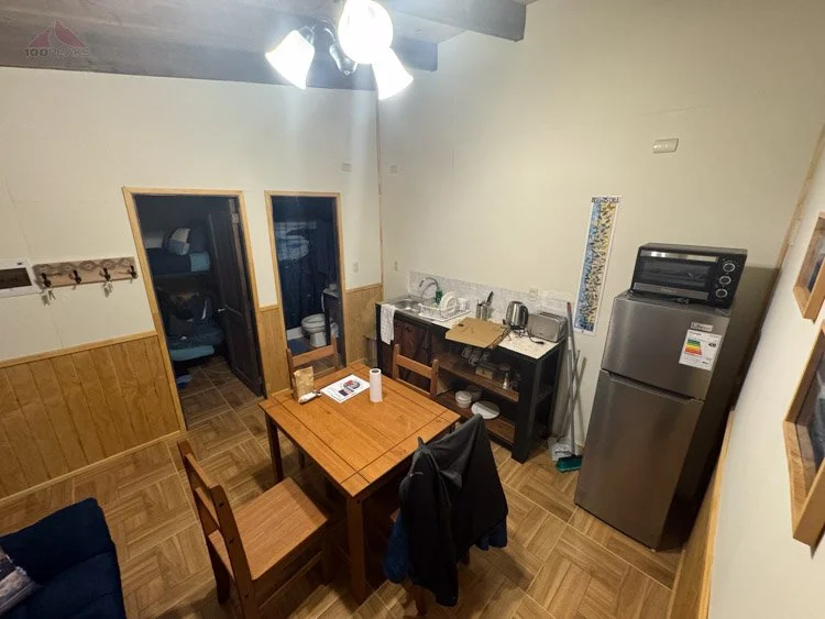
Our first flat in Punta Arenas
Day 3 - Punta Arenas
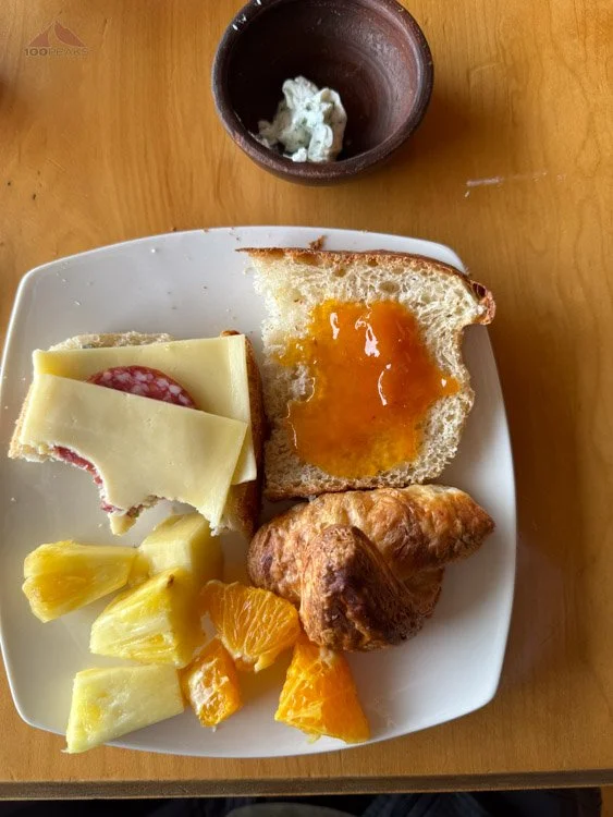
We woke up late and went downstairs. The Airbnb left us a basket of goodies for breakfast, so we made some coffee and enjoyed the breads, jam, and fruit they provided. It was late enough to be lunch.
We lounged for most of the morning before we were ready to explore the town. We strolled around Punta Arenas as the icy wind blew off of the Strait of Magellan and droplets of rain fell from the sky. We were happy to be in layers as we stopped into some shops and made our way down to the waterfront.
It was nice to stretch our legs. We visited the town square with its statue of Magellan and passed the casino.

Magellan statue in the town Plaza
We had some coffee and dessert at a cafe and watched the sidewalk from our perch. We went back to our flat and relaxed for the remainder of the afternoon. The time change caused us to delay our dinner as much as possible.
We headed out and had dinner at a local restaurant near closing time. We agreed to get to bed early, as we had an early start the next day. Luckily, the owners of the Airbnb delivered a new basket for breakfast the next morning, and the meeting point for our boat tour was just a few blocks away.
Day 4 - Punta Arenas Boat Tour
We woke up groggy, happy that our boat tour wasn’t starting at the original 4AM, as it had been moved to 8AM. Punta Arenas is 5 hours ahead of San Diego.
We quickly had coffee and ate breakfast and walked a couple of blocks to the tour office. We entered a room full of people milling about. They told us to be there at 7:45. We were there at 7:40 and appeared to be the last ones to arrive. There was no line, so we waited for some sort of instruction. It seemed people were checking into a desk in the back of the room, so I got in line. A person behind me said this was only for people who hadn't paid yet.
It seemed to take about 10 minutes for every group of people, so it seemed like we were going to be there for a while. Since we had already paid online, I grabbed Soph and we headed out and went onto the waiting bus.
After 15 minutes or so, the final people climbed onto the bus and away we went, driving south along the coast of Punta Arenas. Many of the homes had wonderful views of the Strait of Magellan and there were lupines blooming all over: blue, pink, and lavender.
The rain sprayed against the windows off and on as the bus continued to head south for about an hour. The homes got further apart.
We stopped at the side of the road and we could see our boat below on the sand. It was a large catamaran-style boat and looked solid.

Getting onto the boat for a 12-hour tour
We climbed on and were stopped by a woman with a list of passengers. We were not on it. I opened the app and showed her our paid tickets and we were let on. Perhaps we should have waited in that line back in the office.
We found a small booth near the front of the boat. The other booths were large and accommodated larger parties. Few of the groups were only two, like us.
We relaxed as the boat set off for a tour of about 10 hours. Sophia and I were both a little nervous as the boat rocked vigorously. However, either we got used to it, or the waves subsided a bit, so neither of us had any motion sickness issues.
We were treated with some narration about the history of the area and were provided with breakfast. There was coffee, too.
We were still in awe at being at the end of the world. I remember feeling this way when we first arrived in Greenland. It was hard to believe we actually made it.
Looking out the windows, we saw the green, snow-capped mountains roll by. We got out to stretch our legs and were instantly chilled by the icy winds.
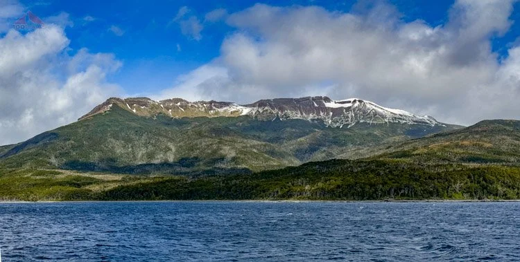
View of Mount Tarn from the Strait of Magellan
We relaxed into our booth and napped here and there. After almost two hours, we were shown the southernmost tip of the South American mainland. Only islands remained to the south of us. We were given lunch.

View of the islands past Cape Froward
After another two hours, we came to Isla Rupert, a small island known to have Magellanic penguins. We cruised the coastline, and sure enough, saw a small group of happy penguins, including a younger one relaxing on a sunny rock. We hung around for a bit and saw some ducks and albatross before someone exclaimed that they saw a spout.
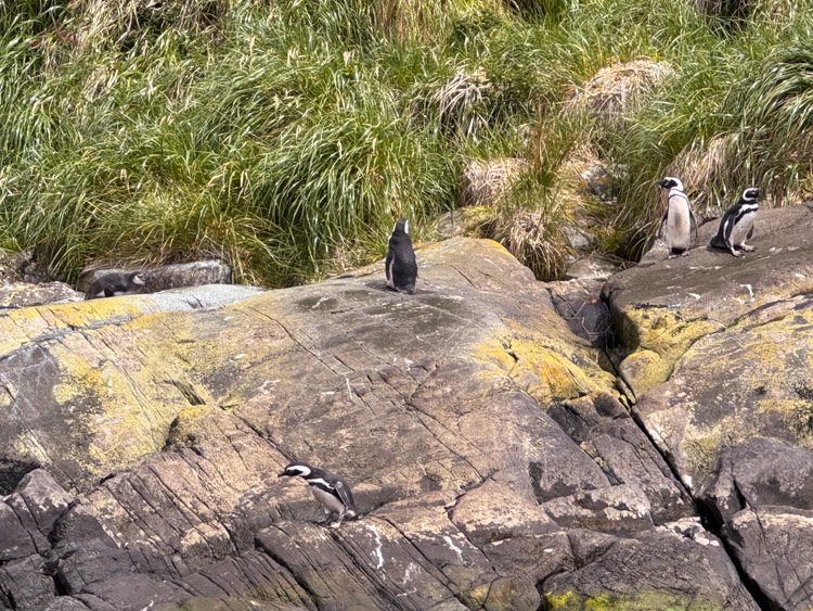
Magellanic Penguins on Isla Rupert
For the next three hours, I saw more whales than I had the rest of my life. We all got out on the bow of the boat and stood in awe of the beasts around us.
They were spouting, jumping, diving, and slapping their flukes on the water.

Humpack whale fluke
After about an hour, wanting to get out of the wind and a break from the crowd, I went to the sunny, sheltered rear of the boat. It felt amazing, and I spotted more whales on this side. I also saw a school of penguins swimming through the water, jumping out of the waves like a school of fish.
I sighed and smiled. Here I was on a boat in Chile watching whales frolic in the water, standing alone in the warm sun.
View of the Chilean mainland from Isla Rupert (Click to enlarge)
It was a magical afternoon.
After three hours of constant whale activity, we headed toward some glaciers on Santa Inés Island. The sides of the fjord rose above us, as thousand-foot tall waterfalls splashed to the sea on either side of the boat.

Heading toward Santa Inés Glacier
The temperature plummeted as we neared the inside of the fjord. Above us loomed a large glacier, impossibly blue. The wind and rain froze our faces as we drank pisco sours chilled by glacial ice. A rainbow hovered near the water outside the fjord.

Rainbow outside the fjord
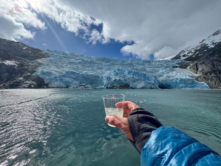
Having a pisco sour with glacier ice

The Samiento de Gamboa Glacier on Santa Inés Island
It was fairly touristy, but it was very fun, and stunningly beautiful. It was time to turn back, so the boat pivoted and began the long journey back to Punta Arenas. We were given dinner.
We stayed in for the evening, snacking on leftover food from the basket and from dinner the night before and repacked all of our things to be prepared for 5 days in the wilderness.

Our daily Airbnb breakfast basket in Punta Arenas
Day 5 - Punta Arenas to Puerto Williams to Laguna del Salto
Dientes de Navarino Trail Map Day 1 (Click to enlarge)
Mileage: 4.79 (7.7k)
Gain/Loss: 2,476’/1,147’ (755m/’350m)
We got up and again had a nice breakfast before Sergio took us back to the Punta Arenas airport to board a flight heading even further south.

The Dientes de Navarino in the Punta Arenas airport.
Our short, 50-minute flight took us over the Strait of Magellan and the Beagle Channel before it landed us on the tiny airstrip outside Puerto Williams. We heard shotgun blasts and wondered what was going on.

The snowy mountains in Argentina from the plane to Puerto Williams
As we waited on the chilly tarmac for our luggage, I got out my phone and opened Peakfinder App. After a few minutes of downloading the local area, I confirmed my suspicions.
From the airport, we could see the Dientes de Navarino, as well as Cerro Bandera, the first mountain we would climb today. There was way more snow than I was led to believe. The ecolodge where we would stay after our trek had indicated that they weren’t expecting new snow. But this snow looked very new.
Hopefully, the trail would stay low and remain below the snow line. [Hint: It wouldn’t]

Dientes de Navarino from the Puerto Williams Airport
We had arranged for Errante Ecolodge, the place where we were going to stay at the end of the Dientes de Navarino trek, to pick us up from the airport and take us to the police department, where we needed to register our trip. They would also take us to the market to pick up some snacks for the day, as well as a trekking store, to pick up some fuel. Utlimately, we were to be dropped off at the trailhead.
We dragged our luggage out to the road and scanned the cars. There was no one holding up a sign. I then saw a van with the Errante logo on the side and a woman walked up, “Derek?”
It was Constanza, the person I had been communicating with while setting up our trip. Her English was excellent and she had knowledge about everything in Puerto Williams and seemed to know everyone in town.
She also let us know that the shotgun blasts we heard were meant to keep the birds away from the airport. They only went off before landing and takeoff.
She first led us to a small adventure store called Tourismo Shila, which sold fuel. I bought two small canisters, just in case, and given that the weather was colder than we expected, I also bought a fleece scarf and Sophia got a buff for keeping the wind off of her face.
The proprietor was very friendly and also spoke excellent English and gave us a map of the area. He mentioned that we wouldn’t need our microspikes, since the snow was soft and not icy. He also recommended some camping spots at various points along the route. We thanked him profusely and exited the store.
At the police station, there was a gentleman sitting with the officer when we arrived, so we knew we wouldn’t have the trail to ourselves.
When it was our turn, we told the officer our plans, showed him our identification, and handed him a sheet I had printed out in Spanish with our itinerary and relevant information. He had me note their email address and phone number in case I needed to communicate to them with my InReach.
“If you need assistance two days into the trip, you should find a way to get yourself out, since we won’t be able to get to you quickly, if at all,” he said.
He logged everything into the computer and into a logbook that looked a lot like a notary’s ledger and we were on our way.
While leaving the station, we walked through a large group of people waiting their turn.
“Were all these people also doing the trail at the same time as us?” Sophia and I asked each other.
The next stop was the market, where we wanted to pick up some food for the road. I was hoping to find some fresh empanadas, but the town seemed pretty shut down and the only thing I could find was a pre-packaged cheese empanada in the fridge. I purchased it and some other snacks and we were on our way to the trailhead.
On the way, we saw the man who was ahead of us at the police station walking on the road. I knew the amount of “good” campsites for our first evening at Laguna del Salto was limited, so I was eager to get going on the trail, especially since that other large group was getting their permit, too.
I didn’t think there were many options for trekking routes on Isla Navarino, so there was a good chance we’d all be vying for tent spots tonight.
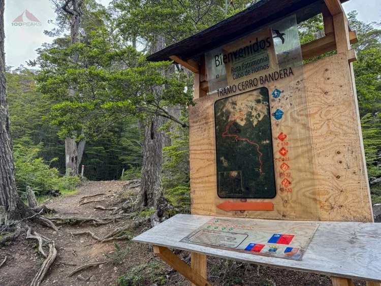
We arrived at the trailhead, which was also for day hikers climbing up to Cerro Bandera. The visitor center was closed.
We quickly rearranged our gear and left two suitcases with Constanza. These contained our non-backpacking supplies for the hotel after our trip. They should be waiting for us at Errante Ecolodge as we emerged from the wilderness.

The Dientes de Navarino trailhead visitor center, which was closed when we started our trek
We thanked Constanza and she drove away, leaving us to pack the remainder of our gear.
“We forgot to take out our microspikes!” Sophia exclaimed.
That was an extra pound or so of dead weight we’d each have to carry for the next 5 days.
“But the trip is only 22 miles, and there will be no elevation issues,” I said. “The first day should be less than 5 miles. Sure, nearly 2,500’ of gain, but still not that far.”
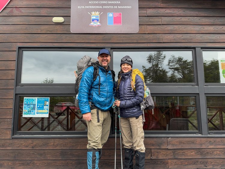
Ready for Dientes de Navarino
We gathered everything, took a photo and headed up the trail. The ground was damp and there were steps and walkways occasionally, to minimize the impact.
Many people hike Cerro Bandera as a day hike
We climbed and climbed until I realized I was low on calories so we stopped at a bench at the crook of a switchback and I ate my cold empanada, sharing it. Not the greatest, but it did the trick. I vowed to have a proper empanada before I left Chile. Sophia had a candy bar, which she also shared.

Darwin's fungus, growing on a tree

The lower part of the trail
We continued upward, with the views of the Beagle Channel and Puerto Williams getting better and better. We stopped briefly at a viewpoint and were again awed by the fact that we were in Chile at the southern end of the world. We could see Argentina across the channel and even Ushuaia in the far distance. We continued upward. I felt good. Slow and steady.

There are a couple of viewpoints along the Dientes de Navarino Trail, which overlook the Beagle Channel

The bent forest
“Less than 5 miles for the day,” I kept telling myself, as the steep trail revealed snow patches that got thicker as we ascended.
We emerged from the trees to another viewpoint, and saw a large group of people taking pictures and putting on their rain gear. The wind picked up, too. The group must have gotten ahead of us while we went to the market.

Getting our rain clothing on as we enter the snowy and windy bald top of Cerro Bandera
Panoramic view of the Beagle Channel and Argentina (Click to enlarge)
As they got back on the trail, Sophia and I donned our rain gear, to keep us warm from the wind and dry from the increasing rain.
We hiked up the last bit to the Chilean flag, which was flapping vigorously in the wind.

The top of Cerro Bandera
A view from Cerro Bandera (Click to enlarge)
“Let’s get ahead of them,” Sophia urged, as she turned right and continued up the wide flat ridge.
In what would be a sampling of the sort of trek this would be, the trail disappeared and rock cairns emerged from the clouds ahead.
We saw one in the distance to the left and one to the right. I knew the trail ultimately side-hilled on the right, so we went that way. The trail was gone again, under the snow and loose scree.

Above the trees, in the wind and rain
As we started descending to the right, which I now know was way too early, Sophia, over the wind, said, “Look, dad, they are way over there.”
She pointed up to the left. I pulled out the map on my phone, and, sure enough, the trail was to the left and stayed high, which would not be the last time I would make this mistake on this trip.

Snow and scree, as far as we can see
We had passed a cairn a while back in this general direction, but we hiked cross-country and got on the trail. It looks like there was still plenty of climbing ahead as we stayed high on the left. We wouldn’t drop for a while.
The rain continued.

Along the trail, the Dientes de Navarino shrouded in clouds
We eventually aimed right as the trail became visible again and started the side-hill experience that I was expecting.
Through the clouds ahead, we caught glimpses of the proper Dientes de Navarino. The snow-capped teeth jutted up into the sky in the distance ahead of us, while the huge Laguna Róbalo loomed about 1,400’ below us.

The Dientes de Navarino in full view
Continuing along the steep side of the mountain, Laguna Róbalo below (Click to enlarge)
I was happy to be on a trail again, crossing the occasional patch of snow, until we came to a large snowfield. The snow was fresh and soft, and the side of the mountain was steep. I didn’t know what was underneath the snow or how stable it was.
We were the first people to hike the Dientes de Navarino since the storm yesterday. There were no footprints ahead of us. A lot had changed in the past week, changing from not expecting much snow to a foot or so deep in some places.
We briefly tried to climb the loose scree around the snow, aiming for some steep outcrops, but keeping our footing was difficult and we’d likely have to cross snow anyway. The hillside was just too steep and loose.
“This is way outside my comfort zone, Soph,” I said, thinking about the snow or the hillside giving away under it. “We either have to go back down to the trailhead and try the lower route, or we go through this steep snow field.”
On the map, there was a lower route, undoubtedly boggy and overgrown, that followed the lake far below us. There was a connector trail to the lower trail on the map, but we had seen no sign of it when we passed that section.
I’ve mentioned it before, like when I turned us around on Mount Whitney in 2020, but I get really conservative in my choices when I am backpacking with Sophia. I’ve taken many chances while alone that I would never subject my daughter to. This was one of those cases.
“Let’s cross the snow field, Dad,” She insisted.

Crossing a steep snowfield, breaking the trail, the Dientes de Navarino in the distance
It was steep, and the exposure was real, but I gripped my poles and stepped into the snow, sinking up to my calf. I flattened the snow ahead of me by stomping down multiple times and took another step.
I glanced to my right. It was a long way down. The rain continued.
While breaking trail so Sophia could easily follow, I was also encountering loose rocks and tufts of slippery grass under the snow. Sometimes I would sink to my thighs.
Sometimes the rock would roll under the weight of my foot, causing me to slip and catch myself, forcing me to break trail around it. Other times, my foot would slip off a slick rock or a grassy hump, carving a chunk out of the snow as I slid sideways a bit down the hill.
I was grateful for my trekking poles.
After a while of focused effort, I was across and it was my turn to watch Sophia go. Since she’s a full 100 pounds lighter than me, she effortlessly floated across the path I had created.

Sophia crossing a snowfield with the Beagle Channel beyond
We breathed a sigh of relief and started down the trail, only to find a string of similar snowfields reaching out ahead of us on the side of this steep mountain. We gathered our focus and crossed each one, aiming for cairns on the far side and trying to avoid the hazards hidden below the snow.
Sometimes she would lead, and the deep snow would pull the boot and gaiter off of her foot.
After some close calls, we reached the end of yet another snowfield when a man caught up to us. He was the man who had been registering with the police before us.
He didn’t speak much English, but between our Spanish and his English we were able to communicate. His name was Jorge, and he said this winter was pretty dry until yesterday, when the snowstorm hit. He also asked if I needed a break and for him to lead in the fresh snow.
I said yes, thank you. I hadn’t realized how tired I was from stomping on the snow for well over a mile on this precarious hillside. He crossed the now smaller snowfields in the lead and we made great progress.
The Dientes de Navarino with Laguna del Salto below. Sophia and Jorge along the snowy trail above the foliage (Click to enlarge)
However, I kept slipping. My boots had good traction, but I would step in the same footprints in the snow that Jorge and Sophia had just crossed and the snow would break off downhill as my foot slipped sideways. Sometimes it would be a smooth rock and other times it would be a patch of grass hidden in the snow.
But more and more, I would find myself on my rear end in the snow with my right leg stretched down the hill. Either my core strength was wiped from side-hilling for this long, or my weight was way greater than the two ahead of me (Jorge was shorter than Sophia). Or both.
During one of these slips, my left trekking pole broke. I was still able to use it for this part of the trip, as the hill was so steep.
I started getting frustrated, as I was slipping all over the place, after watching the other two just scamper across the mountain. I was struggling to keep up.
We then finally reached the part of the trail above Laguna del Salto, where we would descend 450’ straight down to the lake. The slope was a mix of loose scree, loose rocks, and snow patches. It was still raining.
Every step was treacherous and we all ended up on our rear ends multiple times. Our legs were shaking and I felt the effort of breaking the trail.

Dropping down the loose scree and snow slope down to Laguna del Salto
“Less than five miles.” I shook my head.
“Not all miles are created equally,” I thought as I got near the lake and the rocks turned into boulders, still shifting under our weight. My legs were done for the day and my knee hurt like crazy. I must have done something to it during one of my falls.
It was still raining as we looked for a reasonable place to put our tent. Jorge stayed up by a tree on a knoll while we looked for somewhere near the lake.
We found some large bird tracks in the snow. They reminded me of the ubiquitous turkey tracks from back home in San Diego. What bird was this?

What tracks are these?
Since it had been raining non-stop for five hours, anything flat was a large puddle. After waffling with our exhausted brains and roaming back and forth between possible sites, we found a slightly sloped spot and set up camp. It was getting cold, so we hurried. This foggy exhaustion reminded me of Adam and my indecision after a long cold day in the Domelands in 2022.
We’ve done this many times, so before long, we were snug in our tent, making dinner in our vestibule.
As I fell asleep, my knee hurt and was clearly inflamed. I pictured the snowy high country we had seen on the way in. Perhaps a rest day was in order after our snowy first day. Perhaps the snow would melt and the path would be clearer.

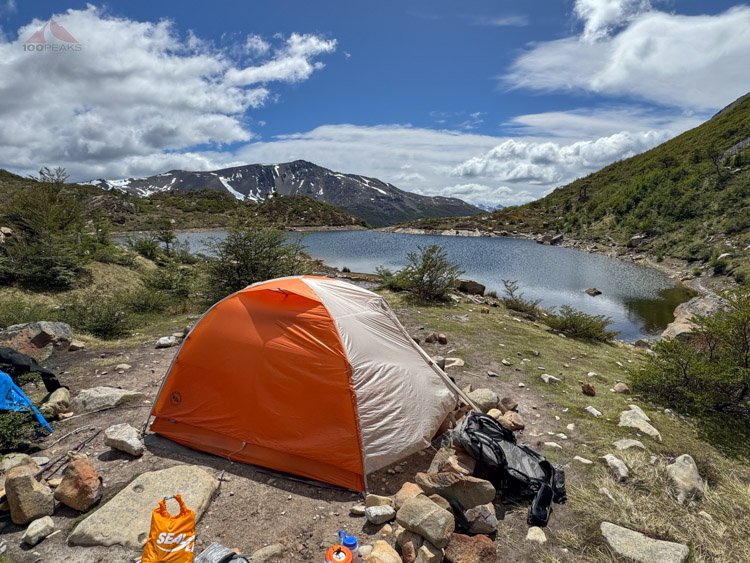
Our tent along Laguna del Salto
At about 11:00PM, we got woken up by a large group of people getting to the lake and looking for campsites. Two women put their tent about 20’ from our tent and proceeded to joke around and sing until very late into the wee hours.
It was frustrating, but also heartwarming to hear their cheerful Spanish and contagious laughter. It was a difficult trail, but they were having a good time.
It must have been the group we saw at the top of the mountain. But where had they gone for four hours? We arrived at camp at around 7PM. Perhaps they had found a path around the snowfields or had summited the top of Cumbre Bandera, which didn’t look safe with all the snow on it.
We fell back asleep once they quieted down and the rain pattered on the tent for hours overnight. We slept well.
Day 6 - Zero Day at Laguna del Salto
Good morning at Laguna del Salto
I woke up and crawled out of our tent at about 11AM. I counted about 18 total people at Laguna del Salto. I hadn’t been expecting this many people.
The other group was packing up and getting ready for the climb ahead. I wished them a good hike.
Another group was slowly packing up near the lake. I had convinced Sophia to take a zero day, so she lounged in the tent, enjoying the warmth of the sun.
Everyone else left the lake, and we had it to ourselves.
My knee was acting up as I strolled around the lakeside. I was glad for a zero day to see if the swelling could go down. We waved at Jorge as he took off for the day.
Much of the snow had melted overnight in the hours of rain. It was sunny now, and more snow was melting. I felt better that our climb over the next few passes wouldn’t be in fresh snow. Any snow we’d cross would also have tracks in it.
Our tent next to Laguna del Salto (Click to enlarge)
We looked at our route on the map. We had removed one day of hiking from our trip and still had around 18 miles left. That left an average of about 6 miles a day, still a very doable amount. Especially if there was an actual trail. [Hint: There wouldn’t be]
We made breakfast on some rocks near the tent and enjoyed the beautiful morning. The rain had petered out a few hours prior and the sun was shining. The clouds would pass overhead, causing a chill, but the sun would come out again and warm us.
We watched a bird that looked like an eagle walk around the lake. It looked like it should be soaring, rather than walking like a chicken. This was the bird that left the turkey-like tracks in the snow in the spot that the women had camped near us. The snow was now all but gone.

White-throated caracara along Laguna del Salto
We got out our wet clothes from the day before and aired them out in the sun and breeze on some large bushes near our tent.

Enjoying a zero day at Laguna del Salto
Sophia went back to the tent to relax and sleep as I explored around the lake. From the cliffs above the bowl that nestled Laguna del Salto, cascades ran down onto grassy slopes. Numerous creeks flowed down through the green and created bogs when the ground got more level. There was an excellent, albeit exposed, campsite on the southern shore of the lake, with a circle of dead wood and a tall deadwood pole.

One of the many waterfalls in the area above Laguna del Salto
After a while, I grabbed a lunch snack and enjoyed a sunny spot on the edge of the lake. As the sun came and went, I watched a pair of ashy-headed geese enjoy the grass around the lake. They were comfortable enough to lay down about 50 feet from me and nap in the warm afternoon.

Ashy-headed geese along Laguna del Salto
A few other backpackers came by and I chatted with them.
One was a couple of Chilean women. One seemed highly experienced and the other not so much. They were aiming to camp a little ways up the trail, just under the informally named Paso Primero. That was a stretch goal for us on our first day, but the conditions had wiped us out on day one.
Another person we met was a solo woman from Denmark. She had turned around the day before us, as she was on Cerro Bandera in the thick of the storm that had coated the area that we had to make our way through on our first day. There had been whiteout conditions on that day, so she was back and had to make up time on the trail. She was aiming to camp at Laguna Escondido, which would have been our destination for today, if we weren’t taking a rest day.
Later in the day, a couple from Canada arrived at Laguna del Salto and made camp in the now-dry campsites on a little knoll across from us. They were aiming to do the standard route and camp in the usual spots.
Sophia and I studied the map again for the next day. We would hike past Laguna Escondida and get as close as we could to Paso Virginia, to set us up for success in getting to Laguna de los Guanacos.
Laguna del Salto after 9PM (Click to enlarge)
“We could have hiked today,” Sophia said.
I agreed, but she took full advantage of our zero day, spending many hours in the warm tent. I was happy to have rested my still-swollen knee.
Once the sun went down, the temperature plummeted and we had dinner in the tent, using the vestibule as a kitchen.
A woman arrived in camp late in the day, quietly setting up between us and the Canadian couple.
We settled into our cozy tent, waking up in the middle of the night to more rain, and ready to get back on the trail tomorrow.
Day 7 - Laguna del Salto to Valle de Lagunas Chevallay
Dientes de Navarino Trail Map Day 2 (Click to enlarge)
Mileage: 6.71 (11k)
Gain/Loss: 2,447’/2,347’ (746m/715m)
After another good night’s sleep, we got out of the tent at around 10AM. We had breakfast as I put out a few items of clothing that hadn’t dried.
The Canadian couple packed up and headed out.

Good morning from our tent at Laguna del Salto
The solo woman, who was named Anne, came over and we chatted. She was from Germany and was on an extended trip in Patagonia. She had already trekked quite a bit along the popular routes in Chile. She asked if she could hike with us. She said she was headed to Laguna de los Dientes, as she heard that Laguna Escondida was windy. Of course we said yes.
We’ve had great experiences meeting people along the trail.
We gathered our things, and at around 12:30PM, we headed out.
We made our way around the lake and climbed up the steep hillside next to a cliff. The trail was essentially a creek cascading down from above. We warmed up very quickly.
The way up is right of center, between the brush and the cliff
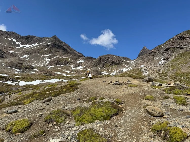
After the steep first part, we came to a little bowl with a lovely campsite in the middle. We were officially above the treeline and in the alpine environment. It was gorgeous, with creeks, tarns, and jagged peaks.

Headed up the unofficial Paso Primero
We climbed a little ridge and crossed over some snow and were on the top of Paso Primero, next to a roaring cascade. This was to be the first of four passes we would climb over the course of the day.
Passing a campsite on our way up

Almost to Paso Primero
We were feeling good. The route was reasonable and the deep snow had melted from the many hours of rain. From Paso Primero, the valley was almost flat to the base of Paso Australia. I took a lot of pictures.

Looking back down the way we came up
Just above Paso Primero, heading up to Paso Australia (Click to enlarge)

Atop Paso Australia
We quickly got to the top of Paso Australia and were treated with a wonderful view of Laguna del Paso. The lake completely filled the cirque below us. We could see some footprints in the snowfields leading off to the right and circling high around the lake.
Paso de los Dientes would be our next destination. We had fun crossing the snow, as it was soft from the sun and we sank easily into the previous steps. We crossed rock fields, sometimes having to use our hands to scramble up boulders. It was a lot of fun and very scenic with the stunning lake below.

Dropping below Paso Australia, with Laguna del Paso below. Paso de los Dientes is high midway along the right side of the lake
Sophia was way ahead of us, enjoying the route, when she sat and waited for us. A bird landed on her knee and then her boot. It hopped up to her shoulder and back down again. She showed us the video later. It was a thrilling interaction with the local wildlife.

Beautiful Laguna del Paso
We started up again and turned the corner to cross Paso de los Dientes and the wind buffeted us. It was like someone turned on a switch.
We descended quickly over boulder fields. There was no trail; we simply walked over loose rocks that threatened our ankles from cairn to cairn as the wind tried to knock us over. I secured my hat to my trekking pole and continued dropping to the side of Laguna del Picacho, staggering from time to time from the sheer force of the wind.

Descending the very windy Paso de los Dientes with Laguna del Picacho in the distance
We picked up a trail on the eastern side of the lake, happy for there to be fewer rocks to walk on. Continuously buffeted by the wind, I stopped to take a picture of the smallish tarn at the southern end of the lake.
“Keep moving, Dad!” Sophia shouted over the gusts. She was struggling to retain her feet. I did just that. I didn’t take another picture for 90 minutes.

A small windy tarn below Laguna del Picacho
In that 90 minutes, we descended past the tarn on a trail that followed the outlet creek and seemed to cross it back and forth. We then followed cairns along the east side of the next lake, although one of the guidebooks mentions to go around the west side of the lake. I imagine that may have been a little easier than our boulder hop along the shore.
We reached the end of the lake and saw a cairn off to our left, we descended down some hills to a little grassy spot out of the wind near a creek.
It was very peaceful to get some silence and feel the sunshine on us. We sat on some rocks and grass and had some food and water. It was a perfect spot just off the trail.
I pulled my phone out and let out a sigh. We had somehow missed the junction in the trail that led off to the west, toward Laguna del los Dientes, Anne’s destination for this evening. We were on the trail that led southeast over Monte Bettinelli and, ultimately, Lago Windhond. Perhaps staying on the west side of that last lake would have kept us on track.
At least we had found this little slice of calm paradise.
I glanced at the map and then back up at the mountain above us. I tried to see if there was a shortcut across, but it was hard to visualize exactly where the trail would be. There were cliffs and walls of brush.
I recommended that we reverse our tracks until we could see the cairns that led to the west. After our lunch, we headed back up the trail and rocks we crossed. Using my phone, I guided us cross-country to a cairn at a shoulder to the west.
We got to the top of the shoulder and followed a trail into the shadow of Cerro Lakutaia. The trail dipped down before it climbed again onto another shoulder in the sun.
A slightly lighter shade of rock led the way across yet another ankle-breaking rock field. We crossed another snow field, before the trail led through some brush and dropped down to the shore of Laguna de los Dientes.

An example of a part of the trail that crosses a rock field. This was common, and we crossed this on the way to Laguna de los Dientes
The trail was nice and flat as we skirted the edge of the lake. We encountered a campsite next to a boulder that was built up with rocks and sticks. Anne said she wanted to check out other possibilities before she chose a spot for the evening.
We continued on until we came around a corner and spied the Canadian couple’s tent. Anne was happy to see them and decided to find a spot nearby. We chatted about the weather and the trail, but, since it was only about 4:30PM and Sophia and I wanted to make up for our zero day, we were going to continue.
We wanted to see how far past Laguna Escondida we could get.
Once again, there was a large gap in photos. I don’t remember making a choice to not take photos, as I distinctly remember how beautiful this area was.
This time, I didn’t take a photo for two and a half hours. I must have been focused on navigation and where I put my feet. This trail (or the lack thereof) made me really appreciate the trail work in the Sierra Nevada and other American trails.
We climbed up a shoulder past Laguna de los Dientes. The area was a lovely alpine area, mixed with granite, bogs, and grass. A creek flowed near the trail.
We descended to the lovely Laguna Escondida. No one was camped at the lake and the wind had mellowed. There were plenty of sheltered campsites overlooking the beautiful water.
If the people below would have hiked about 20 more minutes, they would have had this huge calm lake to themselves. The lake below, Laguna de los Dientes, was nearly as beautiful, so it wasn’t a bad trade.
We hiked past the peninsula that reached into the lake and passed the platform that looked out onto the valley below. We crossed the outlet creek of Laguna Escondida, where Sophia got her feet wet, and continued along a trail that dropped in and out of the forest. It was easy to lose the trail as it either crossed multiple gullies likely caused by glacial weathering or descended through the gullies.
Sometimes we were squeezing through brush and sometimes we were crossing rock fields.
We crossed a large avalanche field and ascended on the far side on some soft grass toward a bowl above. Once we topped out into the bowl, we both were reminded of our time in Greenland, where we spent time in green basins filled with lakes.
The wind picked up as we stopped to get some water at a lovely creek that flowed through the grass. It was already about 6PM, so it was getting chilly.
We saw a lake nearby with a large beaver dam in the middle. We hiked up to another small shoulder and could see the path leading upward on a large knob that led to Paso Ventarrón above.
The trail at this point was reminiscent of many passes we’ve climbed over the years; a trail winding through loose rock and snow patches. Sophia powered up while I had to stop here and there for some breaks. This was the fourth pass of the day, and I was feeling it.
It was, however, fun climbing up and crazy beautiful. Take my word for it.

Almost to the top of Paso Ventarrón, which definitely lived up to its name
We made it to the top of Paso Ventarrón and it lived up to its name. We were nearly knocked over by the gusts. With great effort, I took some quick photos of the stunning Lagunas Chevallay Basin before stowing my phone away. The wind tried its best to rip the phone from my fingers.
The view of scenic Lagunas Chevallay Basin from Paso Ventarrón (Click to enlarge)
Below us, a clear trail through the loose scree led downward into the valley. I remember reading that the trail stays high, but I didn’t realize until Sophia and I had already descended a bit, basically skiing in the scree, that we should have immediately turned right at the crest of the pass, not descending at all.

Accidentally dropping too far down into the basin, but following the path of others, by skiing down treacherously loose scree
Halfway down the slope, I turned and looked back up, since I didn’t see a trail traversing the hillside.
“I saw a cairn up top leading right,” Sophia said.
I missed that. It had been pretty hard to concentrate in the high winds up top and my instinct was to drop as soon as possible. Given the clear trail we were following down the steep slope, it was obvious that we weren’t the first to do so.
We looked below us and could see numerous lakes and ponds in the valley below. The trees looked impenetrable.
“Dad! A beaver!” Sophia pointed to a small pond below us. A head sliced through the water.
Near the bottom, we angled to the right to stay above the brush that grew along the bottom of the hill. We had to climb up a little bit to get around it. We looked at the map and could see that we were far below the actual trail.
We looked up and saw a wall of steep loose scree. The size of the rocks ranged from grapes to a person. And they all just wanted to find their way downhill.
We decided to see if we could ascend back up to the trail. We were concerned that the proper trail avoided a cliff or some other hazard.
The next hour was spent scrambling up a windy steep slope that seemed determined to shake us off. We climbed up the sketchy slope around a large knob. There seemed to be a use trail on the top. However, the actual trail was still high above us.
So we kept climbing.
At one point, Sophia lost her hat and had to crawl back to get it. I checked the map. The trail was still high above us. I did not like the exposure or the high winds and we were both getting very fatigued, so I made the decision to descend. Sophia was concerned about a possible cliff or having to bushwhack.
I told her that we’d make it to the edge of the brush down to the right and see what was there.
We carefully dropped diagonally to the edge of the brush and encountered a faint use trail in the scree. We followed it as it traversed along the loose talus and stayed above the brush. I was able to relax a little as I was confident this was going to keep us high enough to prevent a grueling bushwhack.
We eventually met up with the main trail, as we could see it descending steeply from our right as we descended on another rock field. Our legs were tired as we made the big steps from boulder to boulder.
We made it to the flat lands where we lost the trail many times, avoiding bogs, but enjoying the grassy flatness.
We aimed for a spot on the map that was marked with a tent icon, indicating a campsite. We arrived at the spot at around 8:30PM and immediately sat down on some logs. It was getting very cold so we quickly set up the tent, got some water, and settled in for the evening.

We made it to our planned campsite, along an unnamed pond, taken at 9:15PM
Once again, we cooked our dinner in the vestibule and rapidly got very comfortable and warm. Once fueled, I got out and walked around. There were a few mosquitoes, since there were some bogs and ponds nearby. I surmised we were the only people in at least three miles. This campsite was only lightly used, since most people camp at either Laguna Escondida or Laguna Marillo.
It was silent. The wind had died down. I had on extra layers as I strolled around, enjoying the view of the valley and the sun on the mountains beyond. It was lovely, and the effort of the day melted away.
Our pond for the evening, sunset at 11PM (Click to enlarge)
There was still some light in the sky as we fell asleep about 11PM to the sound of a Chilean bird that we did not recognize.
The clock ticked over to January first. We enjoyed New Year’s Eve in a quiet secluded valley at the end of the world, all to ourselves.
Day 8 - Valle de Lagunas Chevallay to Laguna los Guanacos
Dientes de Navarino Trail Map Day 3 (Click to enlarge)
Mileage: 7.5 (12k)
Gain/Loss: 2,248’/2,175’ (685m/663m)
In the early morning hours, the rain started. We took note, rolled over and went back to sleep.
A few hours later, we stirred and had breakfast and coffee in the vestibule. The rain slowly stopped and the sun came out.
We repacked our things, dried the tent in the sun, and began hiking along the trail. We turned and looked up the mountain we had descended the day before and saw some figures making their way down the steep trail.
We had some climbing to do this day, including Paso Virginia, the high point of the trail. We felt good as we made our way across a few creeks and along a lake.
We missed the trail next to a lake, since it was so nice to walk on the grass. We made our way through some trees, next to a large rocky gully.
We came out of the trees to some granite slabs next to a creek. We easily topped Paso Guérrico and were presented with a striking view of Laguna Hermosa, Cerro Clem, and the snow-capped Argentine mountains beyond.

Sophia atop Paso Guérrico, looking like a warrior, with mountains in Argentina in the distance
The clouds hung over everything, but did not rain.
We dropped down to the southern shoreline of Laguna Hermosa, making our way among the forest of bone-white beaver-killed trees. We made good time along this section and our spirits were high.
The appropriately named Laguna Hermosa with prominent Cerro Clem above (Click to enlarge)
I didn’t take another photo for two hours.
We continued descending across grass, mud, and bushes. We passed several large campsites, including a large site surrounded by a white deadwood fence at the eastern shore of Laguna Martillo. We saw some interesting birds flying in circles over the lake. They looked like geese with thin beaks and let out an interesting honk.
We followed the shore, sometimes near the water and sometimes high above. We took a lunch break at a boggy campsite on the north side of the lake while sitting on logs. We continued on, opting to climb a steep knoll on the lakeside, rather than follow the edge of the lake.
We dropped steeply down the other side and trekked through some boggy bushes until we encountered another shoulder with a great view of the valley below. There was a campsite here that took advantage of the wonderful view of the river.

Just past Laguna Martillo, Sophia looks at the mountains in the distance. A campsite with a windbreak is here.
It’s hard to overstate how hard it was to stay on the trail, as it appeared and disappeared within a few yards. We had to carefully cross sometimes knee-deep bogs that squeezed through overgrown foliage.
We continued down the valley until we climbed up a steep hill and could see our route ahead. The large Virginia Massif loomed above a few lakes that we would weave around.

The impressive rock spires of Montes Lindenmeyer along the Dientes de Navarino

Climbing steeply past Laguna Rocallosa, toward Paso Virginia
We stopped at the top of the hill and had some water. We were already pretty tired and we still had a long way to go. Immediately ahead of us was a ridiculously steep and muddy descent onto a small flat.

An example of the muddy parts of the Dientes de Navarino that reminded us of The Arctic Circle Trail
Multiple times along the Dientes de Navarino trek, the trail would just go straight down. Sometimes we would have to downclimb by hanging onto trees, stepping over roots, or finding the right sequence of stones or sticks to step on. Sometimes, it was just a muddy cliff that we would just have to figure out how to descend without breaking our necks. This was one of those.
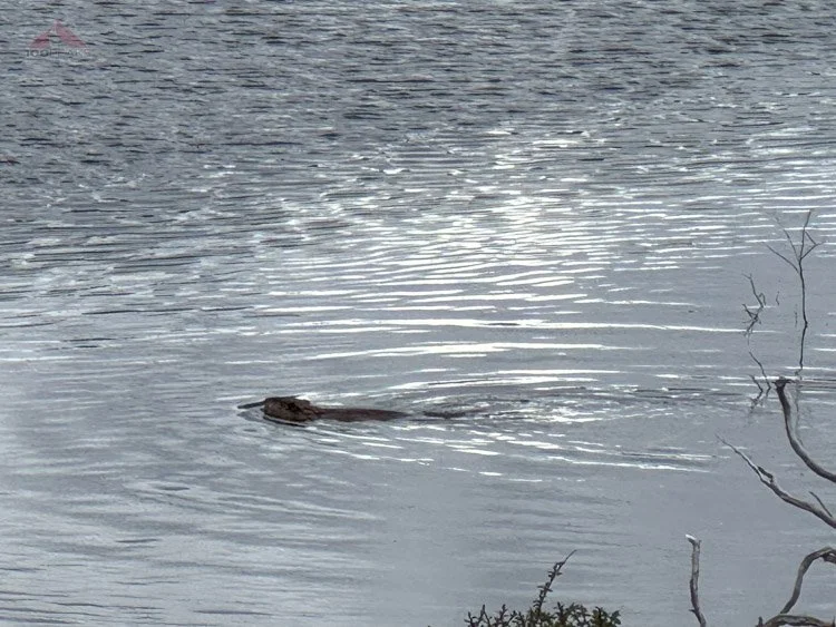
Another beaver sighting, this time in Laguna Islote
We carefully dropped down, holding onto tree branches and high-stepping over roots, onto the plain below and crossed a raging river, filtering some water along the way.
We made our way up past a pond, making our way around the long and thin Laguna Rocallosa before climbing steeply up a wooded hillside. On top we could again see our route ahead. We dropped down another treacherous steep and muddy hill onto a boggy plain.
The route before us would climb over 1,000’ in .75 miles, which is pretty steep. I knew the ridge ahead was only the first part of the climb.
We crossed the plain, losing the trail here and there, as we followed the shoreline of Laguna Islote. We stopped for a few minutes to watch a beaver swim around the lake before we could see several use trails leading straight up the mountain.
We chose one and were almost immediately in thick forest. We scanned the blanket of the forest floor, looking for the trail. I checked my GPS frequently, correcting every hundred feet. The trail was, at best, faint at times and nowhere to be found at others. Our progress was slow in this steep lower part of the climb. We wondered how everyone else had made their way through this trailless section of the forest.
We finally crossed muddy section after muddy section until we came to a rock outcrop. We paused for a second to check out the view. The mountains across the valley were breathtaking, as was the valley below.
Climbing the bottom part up toward Paso Virginia (Click to enlarge)
Our view into Valle Guerrico with the Montes Lindenmeyer above (Click to enlarge)
We made our way around the left side of the outcrop and came upon a muddy hillside. Two steps forward and one step back was the name of the game for this section. Sophia scampered up quickly while I carefully made my way. She disappeared around the corner of some bushes.
I reached the bushes and was happy to see an actual trail on the scree. It was steep, but it was dry and visible. We started making good time, slowing a bit on the steeper sections, which became more frequent. Sophia was again speeding up again while I stopped to regain my breath from the climb. I called ahead to let her know that the top we could see was just a shoulder before more climbing.

Climbing higher toward Paso Virginia
She rested on a large boulder high on the mountain next to a raging cascade. The view below was opening up and was a treat while I caught my breath. We could see all the way to the Beagle Channel, many miles away.
I let her know that the trail was to the right and she was grateful for the information, as her instinct would have led her across the cascade to who knows what on the other side.

Sophia at the top of the steep part of Paso Virginia. Still a long way to go
We made it to the bowl at the foot of Paso Virginia. I was tired, but happy that the trail wasn’t as steep. A small tarn sat in the center of the rocky terrain.
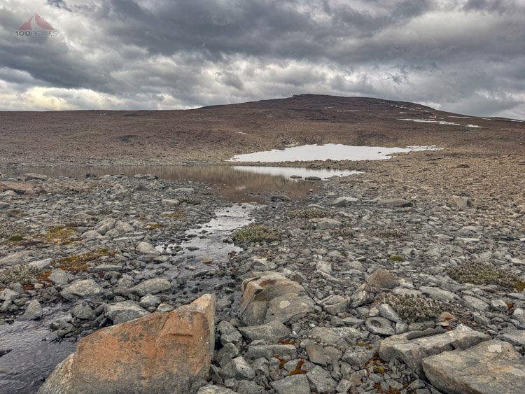
A small tarn below Paso Virginia
We sat for a few minutes, drinking some water and having a snack. We were eager to be almost done with the final big climb of the trail.
Sophia, knowing that the end of the trail, and the Errante Ecolodge was less than 4 miles away from our campsite this evening, started thinking about making it all of the way out today.
I looked at my phone. It was almost 8PM already. On a reasonable trail, I would say “Let’s go for it.” But this wasn’t a reasonable trail. She insisted that we try and I told her I’d consider it.
We made it to the top of Paso Virginia and the views were amazing. I paused for a second.

Sophia atop Paso Virginia
Looking back from atop Paso Virginia (Click to enlarge)
The Beagle Channel from atop Paso Virginia (Click to enlarge)
“We have to camp on the far side of that?” I pointed at the body of water below. It looked impossibly far.
That’s because it was. We moved forward toward the edge of the pass and we could then see the much smaller Laguna de los Guanacos immediately below us. And by immediately, I mean immediately.

Laguna de los Guanacos from the top of Paso Virginia
The trail descended straight down the other side, a soft scree hill that dropped 1,000’ in less than half a mile.
We scooted forward. The first part of the “trail” was an exposed sandy hillside that had been eroded clean. Our feet would easily slip on anything we put our weight on. We slid on our backsides, navigating from one small embedded rock to another.
The exposure was real. We could see two figures watching us from far below.
We finally made it to the deep scree section. The passage of others had made the route visible, exposing the lighter scree from under the darker surface. It took a few minutes, but we got our rhythm; one step, slide three feet down. Next step, three feet more.
It was almost like skiing on scree, sometimes turning my body one way to favor one leg and then turning quickly back to favor the other. There was a second during every turn that my body was in danger of falling forward or that my feet would both slide forward in the scree, but I would catch myself with my downhill leg.
It took us an hour to get to the other side of the lake. By that time, my legs were done and my hip was on fire. Nine hours on uneven terrain with only a few hundred feet of actual trail had worn everything out.
Sophia was fine and eager to get all the way down to the lodge. I let her know that it’s probably not going to happen. I was getting really fatigued and it wouldn’t be wise to overdo it in this terrain.
We crossed yet another boulder field and my legs could barely do it. Luckily, the trail on the northwestern side of the lake was reasonable for the most part. Sometimes, however, the trail would turn and go straight down the hillside, covered only with slippery dirt and gravel, daring us to fall.

Looking back up the loose scree path down Paso Virginia
We again watched a beaver frolic in the water below us, occasionally slapping its tail at us.
Ahead, we could see the lookout platform at the end of the lake. The campsites were around there somewhere. The man at the outdoor store at the beginning recommended staying at the lake below this one. I was willing to give that a shot, even though I was exhausted.
We finally made it to the edge of the lake and could see a few tents. A woman came out of the brush to chat with us as we passed the campsites. We were about to continue descending.
It was the Chilean woman from our zero day who was with another woman. She asked what our plan was and I told her that I was done for the day, but my daughter wanted to continue to the end.
She said that wouldn’t be wise, since the trail ahead was just as challenging and would take about three and a half hours to go the remaining three and a half miles. And trying it in headlamps would be a bad idea. Sophia heard the woman’s recommendation and acquiesced.
We crossed the raging outlet stream and climbed up to an exposed but gorgeous campsite near the edge of the lake. We looked back at what we descended. We were both very, very tired.
Although the evening was still, I lashed the tent down, using every guyline available. The ground was hard, so I used large rocks and branches. Earlier on the trip, I had perfected a method of using trekking poles as anchors for the vestibules, instead of stakes.
It took all the remaining strength I had to go down to the edge of the lake and fill the water bladder and get everything under the vestibule. We were cold, but once again were cozy in the tent with our hot meals. We ate everything we could and slept incredibly well.
Day 9 - Laguna los Guanacos to Errante Ecolodge
Dientes de Navarino Trail Map Day 4 (Click to enlarge)
Mileage: 3.5 (5.6km)
Gain/Loss: 257’/1,953’ (78m/595m)
We woke up to the tent hitting us in the face. Gusts of wind were coming down from the pass we had descended the evening before, sending rain spraying sideways onto the tent, like someone was standing near the lake with a firehose.
Some of the guy lines had gotten free from their lashings. I hadn’t been extremely careful, since it was so calm and still the night before.
I pushed up from the bottom of the tent to keep the roof off of us, enabling the tent to regain its shape and prevent the tent poles from snapping. I did this a few times and turned on my phone. It was around 7AM.
Not long after, an enormous gust flattened the tent again, threatening to smother us and break the poles. I pushed the tent back up.
And there I remained for a full half-hour, laying on my side, propping the tent up with my arm outstretched, as what felt like an honest estimate of sustained 50mph (~80kph) winds howled onto us, bringing with it hard rain. It wasn’t a gust or series of gusts. It was a solid 30 minutes of the loudest and strongest unrelenting wind I’ve ever been privileged enough to experience in a tent.

Our campsite at Laguna de los Guanacos, less than one hour after the raging storm
After a while, it diminished to normal 30mph gusts and rain. Sophia, rolled over and went back to sleep while I occasionally propped the tent back up.
At 8AM, the wind and rain stopped. 45 minutes later, I emerged from the tent to a sunny, cloudless sky, with no wind whatsoever.
Beautiful Laguna de los Guanacos (Click to enlarge)
“Let’s get up and have breakfast and pack while it’s sunny,” I encouraged.
We started packing in the wonderful sunshine. I put out some items to dry.
I walked over to the viewing deck and made my breakfast and coffee. It was nice to sit on a bench in the sun and lean back. I chatted a little with two men who had been sleeping nearby when we arrived the night before. They were Chilean and were enjoying the trail.
By the time we were putting the finishing touches on our packing, the clouds had come in and the temperature had dropped. It was time to go.

A half an hour after the sunny morning, we were enshrouded in fog and the rain started
After crossing the outlet stream of Laguna de los Guanacos just below our campsite, the trail immediately dropped straight down on sketchy dirt to cross it again. The two men, who had left way before us, were just on the other side. They must have walked up and down the bank to find a good way to cross. We saw a nice spot a little upstream and were across in no time.
We were immediately wondering where the trail was under the fallen leaves on the forest floor. We high-stepped over some fallen trees and saw footprints in the mud.
We passed the large group of people that had camped near us at Laguna del Salto on our first night, saying hello. They were packing up from their overnight stay near Laguna de Las Guanacas, a pond just below our lake.
Sophia and I continued on, hopping over some inlet streams and circling the pond. We made quick time on the trail, on the bottom of a flat valley. Like most of the route, we lost the trail repeatedly. The two men ended up high in the woods while we kept to the valley floor. We crossed muddy sections and squeezed between overgrown bushes.
The trail entered another broad plain before it turned into the forest. Our pace slowed to a crawl. We had to cross deep muddy bogs, climb over large logs, and try in vain sometimes to find the trail.
After crawling on all fours under a tree, following a clear trail, it suddenly disappeared. I got out my phone and confirmed that we were off trail. The two men came up behind us, also following the trail that went nowhere.
I knew the trail was several hundred feet to the east, so Sophia and I headed through the thick rainforest, climbing over more deadfalls and trying to fight our way through the dense foliage. We were happy we hadn’t tried this in the dark with our headlamps.
We finally hit the trail again and carefully made our way through the forest. The trail emerged onto a high slope, with wonderful views of the Beagle Channel.
Getting closer to the end of the Dientes de Navarino Trail (Click to enlarge)
From this point on, there were use trails all over, some made by humans, but many made by livestock. After climbing over a treed hill, the trail once again emerged onto a green hillside.
I kept my phone out, since the trail was almost never where we expected. We were generally headed in the right direction, side-hilling it on a grassy slope in between large bushes. We came across the carcass of a cow.
We descended and entered another forest. This time, there were markings on the trees, telling us where to go. The leaves from the trees had covered up any discernible trail and the bright marks on the trunks were at the perfect height on the trees ahead.
Until there wasn’t. The markings disappeared and I had to get out my phone again. I wondered how other people had found the way on this trail. They must have either had a guide, or had help with a GPS.
The trail took a sharp left turn and once again headed out onto a grassy hillside. I slipped on a log and landed in a bog. It’s always when you’re almost done that these little accidents tend to happen.
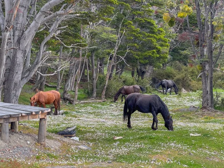
We topped a ridge overlooking the channel and encountered some wild horses grazing on a grassy mesa. The Dientes de Navarino Trail connected to the Cascada los Bronces, a popular day hiking trail. We dropped down to the road and high-fived each other.
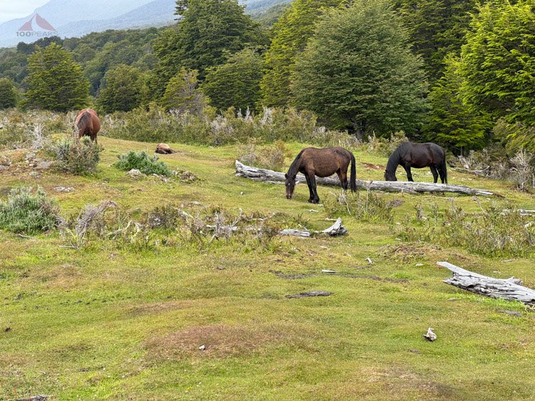
Wild horses on the last bit of the Dientes de Navarino Trail
We still had a little ways to go, but were happy to be on the road, where we weren’t losing the trail every few minutes. We caught up to two women we had met on day two, and again at the lake the previous evening.
“How is it possible that you don’t have any mud on you?” I asked.
Sophia and I had mud up to our knees, as we had crossed many bogs throughout the day. Perhaps we had just sped through the trail, and they had been careful to avoid the mud somehow. She, shrugged, said she was a guide, and had done the trail many times.
We walked a bit on the road and a dog came bouncing along the road.
“Benito!” one of the women exclaimed.
Sophia and I recognized the name. We knew there was a resident dog at the Errante Ecolodge named Benito. We greeted him and he followed us along the road, running way ahead of us.
It wasn’t long until we reached the Ecolodge. There was a sign on the road, but nothing on the building to indicate where the entrance was. We took a guess, and entered. Benito followed us. We came across Constanza and were happy to see her. We asked if we could have lunch.
“Do you have any food allergies or preferences?” She asked.
We shook our heads no, saying that we ate everything, and headed to our room, which ended up being very comfortable with a lovely view of the channel. We enjoyed our showers and relaxed on the bed until lunch time came.
We came out to eat and were ushered upstairs, where, once again, we had a great view of the channel. We were the only two people in the restaurant and bar. We were led to a table with water and we realized that there were no menus. We simply ate what the chef made for us.
What followed was some of the best food we had eaten in awhile. It’s hard to overstate how satisfying this food was. We were overjoyed with the personal service and quality meals we received at Errante Ecolodge.
I highly recommend it for anyone visiting Puerto Williams.


We spent the day relaxing in our room, communicating with loved ones, and reorganizing our gear to fit back into our suitcases.
And we had a wonderful dinner as well.


Day 10 - Errante Ecolodge and Puerto Williams
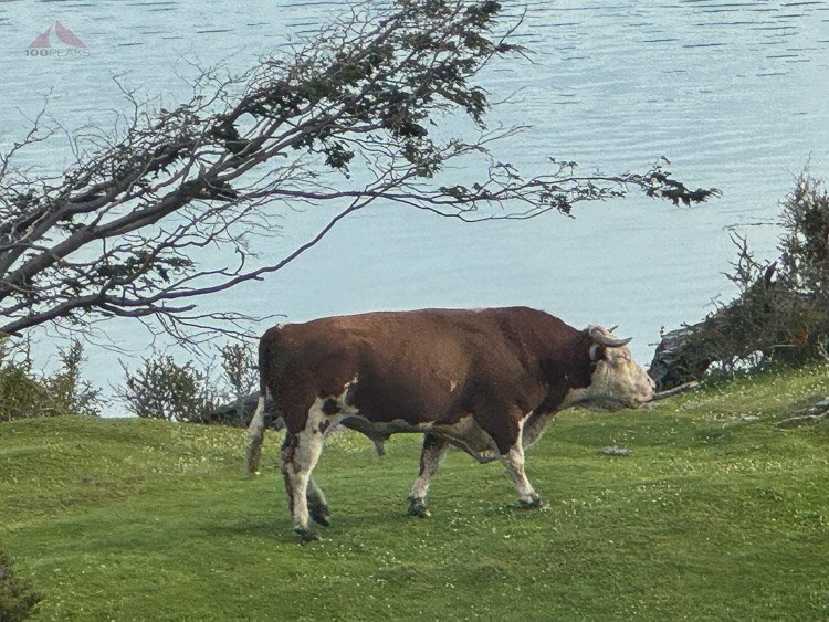
The loud morning bull from our room
I woke up to the sound of a large bull bellowing its dominance on the grassy hill below our room. As I shook myself awake, I realized I had assumed it was someone snoring in a neighboring room.
I stood there, watching the bull scratch its horns on a fallen log. The view from the windows looked out to the channel and mountains in Argentina. It was time for breakfast.
Breakfast buffet
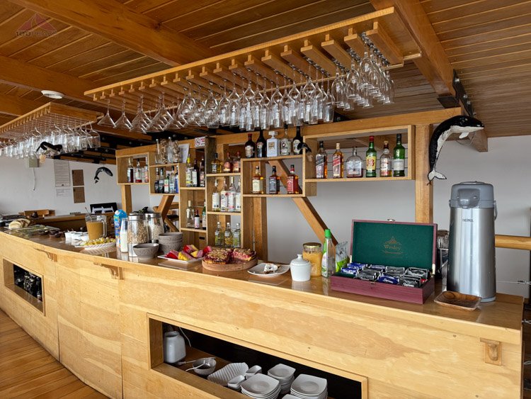
The bar at Errante Ecolodge
We then got picked up by a gentleman named Nelson who would take us on a horseback ride. Nelson spoke little English, but spoke Spanish slowly, so we communicated with no problem.
He drove us to his stables, and selected some horses for us. His host of dogs came along for the ride.
Along the ride, we were accompanied by the best weather we had experienced on the trip. As the horses rode along the channel, the sun shone down upon us. The dogs frolicked around us, chasing the geese and each other.

Our view from the horseback riding
We saw the large group from the trail and waved hello. We could see the Dientes de Navarino in the distance and exclaimed how little snow there appeared to be.
Sophia and I grinned from ear to ear and we repeated how gorgeous the day and setting was. The horses carried us along the water, across rivers, through fields of flowers, and into the forest. We saw beaver-killed trees and rode through mud.
A beautiful day riding horses at the end of the world on Isla Navarino
The Beagle Channel from our horses (Click to enlarge)

Enjoying mountains from our horses
Isla Navarino beauty (Click to enlarge)

Riding through the forest

Encountering wild horses
We encountered a herd of wild horses, whose black stallion challenged Nelson’s stallion. After a few hours, we crossed through some gates and returned to the stables.
It was a wonderful horseback ride and Nelson was knowledgeable and patient. He obviously loves his horses and dogs. Sophia enjoyed a cuddle session with his dogs before we drove back to the Ecolodge.
She also enjoyed another cuddle session with Benito.

Benito, the true king of Errante Ecolodge
We had originally told Errante that we would eat in town for lunch, but we changed our minds once we realized that the best food we’d probably get would be here. And it was true.


We then caught a ride into town and walked around. We had to let the police know that we had returned safely. Unfortunately, the police station was marked incorrectly on the map, so we wandered through a neighborhood that didn’t look familiar.
We noted that most of the businesses were closed and we would have been hard-pressed to find a restaurant open for us.
We asked around and got directions to the station. We checked in with the police, noting that Jorge, the man we had hiked with on day one, had checked in the day before us.
Having fulfilled our duty, we strolled along the town, looking for souvenirs, and getting some snacks and drinks at the local market.
We sat on a bench overlooking the harbor and enjoyed our treats. Our conversation wandered all over as we savored our final hours in Puerto Williams. We pet some wandering dogs and cats. A herd of wild horses came into town, grazing on the grass in front of some of the buildings.
We walked down to the harbor, where our shuttle would pick us up and enjoyed looking at the ships and once again could see the Dientes de Navarino.

Puerto WIlliams with Dientes de Navarino behind

Dientes de Navarino
We made it back to Errante Ecolodge and hung out on the rear deck, petting the local cat, and enjoying the mild evening outside overlooking the water.
The view from outside our room at Errante Ecolodge (Click to enlarge)

The jacuzzis at Errante Ecolodge

Looking into our room
A herd of wild horses came by to graze on the grass next to the lodge. This place was wild.
Wild horses outside our room
After relaxing in the room, we had dinner at around 8PM. It started raining during our dinner and we returned to our room to pack for our next step to Punta Arenas.

The view from our room at Errante Ecolodge

The view from our table at Errante Ecolodge


Day 11 - Puerto Williams to Punta Arenas
Our flight was scheduled at 11:30AM. The airport was tiny and a few minutes away, so we enjoyed our breakfast while waiting for our ride. I checked out of our room with Constanza, making sure I tipped Nelson for the wonderful horseback riding.
Constanza then drove us to the airport, explaining the challenges that Isla Navarino has faced since the COVID-19 pandemic. Businesses have struggled, but she feels that there is hope in sight.
We arrived at the airport and said our goodbyes. The service and amenities at Errante Ecolodge far exceeded my expectations.
We got into the airport and checked in after a wait. It was very casual. We had to pay for our bags being heavy, but it was a small amount. We walked out onto the runway and Sophia admitted she was a little nervous about flying on such a small plane.

Our tiny plane from Puerto Williams to Punta Arenas

Inside the tiny plane
We took off, and once we were in the air, we had a wonderful flight over wild country, devoid of roads and cities.

Tierra del Fuego from the plane
We landed in Punta Arenas and got picked up by a taxi driver arranged by our Airbnb. The rain came down as we got settled into our flat, another charming property in Punta Arenas.
Our second comfortable flat in Punta Arenas
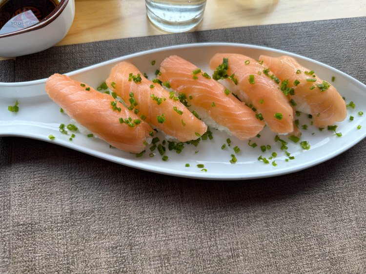
We relaxed again from the flight, reading the information left by the host and decided we wanted sushi for lunch and walked out into the rainy day. We strolled through the streets again, and found a sushi place and had a wonderful lunch while looking out the window.


Then it was time to shop for gifts and we went from store to store, through the rain, enjoying our time in Punta Arenas and our final day in Magellanes.
For a later dinner, I strolled through the rain and picked up pizza nearby to enjoy in our flat. We were ready to go home, but had one more adventure to go.
Day 12 - Punta Arenas to Santiago (Maipo Valley)
We woke up and headed back to the airport. We had a 10:30AM flight headed home with a 10.5-hour layover in Santiago.
What did we do? Like we normally do, we made the best of it.
Since our large suitcases were checked all the way to LAX, we exited Santiago airport and met our driver who spoke excellent English. We were signed up for wine tours to two wineries in Maipo Valley, but first, empanadas. We had booked a wonderful trip from Maipo Valley Wine Tours. It was great that they were able to pick us up and take us back to the airport.

Empanada on our tour in Maipo Valley
We stopped off at a restaurant and enjoyed some fresh empanadas, way better than the one I had on the first day on the trail.
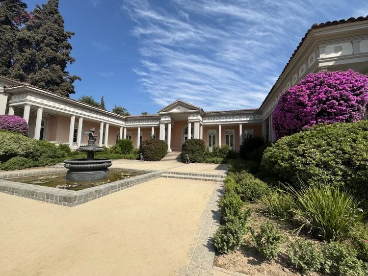
Concha y Toro estate tour

The barrels of Concha y Toro
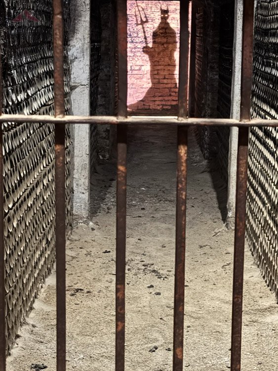
El Diablo

Wine tasting at Concha y Toro
We then went on a full tour of Concha y Toro winery, and then a private dinner at a lovely tiny vineyard called vinos Lof.

The lovely terrace at Vinos LOF
Sophia and I had a sunset dinner at Vinos LOF on a terrace overlooking the vineyards and valley. The food was made by the winemaker’s mother and was excellent. It was paired with the vineyard’s wines and the winemaker explained his process and the intent of the vineyard. The syrah, my favorite varietal, was delicious and paired well with the fresh salmon dinner.


As we ate our dinner in the breeze of the early evening, we reflected on all of the crazy, wonderful adventures we had on this trip and how fortunate we were to be able to experience them.
We had been able to enjoy a slice of Chilean culture, as well as backpack through the Dientes de Navarino.
We spent hours watching penguins sun themselves and whales frolic in the frigid waters at the southern tip of South America, enjoying the wild country of Tierra del Fuego.
We enjoyed some amazing cuisine at the end of the world and rode horses on an island only a few hundred miles away from the Antarctic Circle on a perfect sunny day.
We enjoyed the summer weather in Maipo Valley while eating some wonderful dinner and met a lot of friendly, generous people throughout Chile.
We were ready to get home, but happy about the new collection of experiences we had gathered.
We clinked our glasses and finished our meal before heading back to the airport and home.
The lovely Vinos LOF in Maipo Valley, a perfect way to end a long adventure (Click to enlarge)

